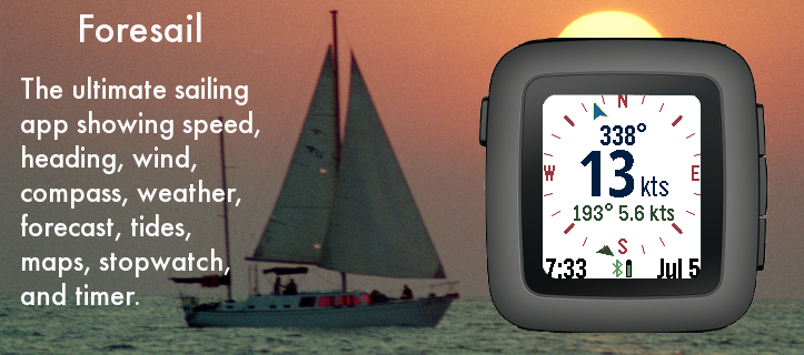
The ultimate Pebble sailing app! Displays your realtime speed and heading, along with wind speed and direction on a compass dial.
Other screens include the current weather conditions, weather forecast, tide information, a zoomable map, and a sailing timer. You can switch screens using a long press to the up or down buttons. The select button on the Pebble activates the screens and settings menu.
Speed and bearing is calculated using the smart phone GPS. Use the up and down buttons to zoom the map. The menu has a button for refreshing weather (or the map if it is visible).
Select from several different weather services, including OpenWeatherMap.org, Yahoo Weather, NOAA, and the commercial service Forecast.io for premium subscribers. If tide is activated, the nearest NOAA or Canadian station is used to display tide information. GPS is used to find the closest weather station unless a manual location is entered.
Customizable settings include the speed units (knots, mps, mph, kph), temperature scale, air pressure, date format, battery, connection, vibration alert, backlight, and more. SetPebble subscribers have access to Forecast.io weather information and more-frequent updates.
Mapping tiles Copyright and courtesy of OpenStreetMap, OpenStreetMap contributors, Google Maps, ESRI ArcGIS, Stamen, and NOAA. Stamen data by Stamen Design (http://stamen.com); OpenStreetMap (http://openstreetmap.org) mapping tiles under Creative Commons licenses.
Latest Version: 1.9
Version History:
0.0 Created July 4, 2016
1.0 Released July 10, 2016
1.1 NOAA depth charts, Stamen, ARCGIS, OpenStreetMap added
1.2 Glance and Pebble 2 support
1.3 Recompiled for firmware 4.0.1
1.4 Sped up initial load
1.5 Patch for new Pebble Time Android
1.6 Forecast.io is now Dark Sky
1.7 Last update time fix
1.8 Fixed PWS support
1.9 Manual latitude/longitude fix